
A New Approach in Plant Physical Documentation and Information Management for Existing Facilities, Part I

Dr. Moh Hashemi, PE & David S. Reinhart
INOVx Solutions
Ed. Note: In keeping with our focus on the use of CAD software in plant design/redesign, the following story addresses the use of laser scanning/photogrammetry technology for plant physical documentation. The process will be covered in two parts.
Traditional Plant Documentation – The Manual Approach
Plant physical documentation is the recording of accurate dimensions and relative locations of all objects in a facility and classifying the objects in their appropriate engineering discipline such as equipment, structural, electrical, civil, etc. The plant physical documentation defines the "as-is" or "as built" conditions of the plant and it is required for many revamp/retrofit projects and operation and maintenance activities.
Accurate, up to date "as built" plant physical documentation does not exist for many older facilities. Rather these facilities typically use obsolete two dimensional manual or CAD drawings such as plot plans, elevation drawings, systems isometrics, etc. prepared during the original engineering and construction phase or during a major revamp or retrofit project.
The manual approach for collecting and updating the plant physical conditions is commonly used for most revamp/retrofit projects and plant operation and maintenance applications. For revamp/retrofit, the lack of accuracy obtained in the manual approach is generally compensated for with design contigencies. Engineers understand that different engineering and operational disciplines must make multiple passes to manually collect the specific data they need, and accept the impact on both project budget and timeline. In addition, the manual data collection is rarely passed between disciplines or from one project to another, which results in an ineffective use of collected data.
3D CAD – Applications in New and Existing Facilities to Date
Newly completed plants often use 3D CAD models developed during the engineering and construction phases of the plant for physical documentation. Many owner/operators recoginize the importance of these documents for operation and maintenance activities and the future revamp and retrofit projects. The 3D models are used as a living document and are updated continuously as plant conditions evolve. The 3D CAD model also serves as an excellent information management tool. 3D visualization also simplifies the query and display of the plant information associated with these models. Therefore, the 3D models are used as effective plant data mining tools.
3D modeling has been promoted as an effective methodology for physical documentaion of the existing facilities due to the positive results realized with the engineering, construction, operation and maintenance of new facilities using these models. However, many belive that development of complete and detailed intelligent 3D models of an existing facility is expensive and impractical in the absence of accurate existing "as-is" engineering documents. Therefore, the owner/operators, and engineering and construction companies rarely use 3D modeling technology for their revamp/retrofit projects, and the operation and maintenance activities.
A New Approach to Plant Documentation
Laser scanning and imaging, and close range photogrammetry are effective technologies for physical documentation of existing plants. They are advanced three-dimensional measurement and visualization tools that develop the physical database of an existing facility. The resulting physical database can be used independently for many applications or, if required, to develop a complete and dimensionally accurate CAD model for multiple uses in existing facilities on a scalable and fit-for-purpose basis.
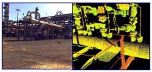
The laser scanning and imaging process involves capturing through a camera-like instrument, or laser scanner, a "cloud of points". The cloud of points represents the field of view of the scanner and contains three-dimentional point data of the area scanned. A collection of "clouds of points" makes up a 3D, spatially accurate database in which scanned objects can be reviewed, located and measured. The clouds of points are referenced back to the facility coordinate system by three-dimensional surveying targets which are strategically located throughout the area captured by laser scanning.
Photogrammetry is similar in many respects to laser scanning and imaging. In photogrammetry, the object itself is not measured, but rather, measurements are taken from stereo photos of the object. Multiple photos are taken of each area and referenced to the facility coordinate system by temporary adhesive targets which are strategically located throughout the area. They are then surveyed and captured by photogrammetry. The photos are linked to the survey points and used to determine additional three-dimensional coordinates through triangulated measurement, making it possible to accurately collect the location, sizes, and shapes of all visible objects within an operating plant.
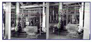
Photogrammetry has been applied on numerous revamp and retrofit projects for more than a decade. In its developmental years, close range photogrammetry was used in Europe for documenting existing nuclear facilities on revamp/retrofit and dismantling projects. For these types of projects, photogrammetry significantly reduces the field work for collecting data and the preparation of a CAD model when compared to a manual approach. The benefits of photogrammetry technology for the existing facilities is well documented in open literature.
The laser scanning and imaging process is a newer data collection technology. This advanced technology has the capability of creating an instantaneous 3D representation of a scene -- or the "cloud of points". Laser scanning has proven on many projects to significantly reduce the cost and time required to collect data when compared to manual means.
Various types of photogrammetry technologies are available commercially. Photogrammetry is a mature technology and one which is more dependent on software rather than hardware or firmware in comparison with laser scanning technology. Most commercial photogrammetry packages offer reliable and accurate systems with similar functionalities. The differentiating characteristics between them are the cost and effectiveness of the 3D modeling activities.
At least four types of laser scanning systems are available at this time. Laser scanning is a less mature technology when compared to photogrammetry and it is highly dependent on the hardware and firmware. Laser scanner systems differ in terms of cost; data collection targeting and range; system portability; hardware; and electronics reliability, availability and maintainability. Currently, these issues are key concerns of most users.
An Effective Combination
While it is generally accepted that many areas in existing facilities can be captured easily by either of these technologies to create a physical database, the integration of laser scanning and photogrammetry data collection methods is an effective course for effeciently documenting up to 100% of an existing facility.
Laser scanning is the most effective tool for physically documenting the hard to reach places. Photogrammetry provides the most effective method for documenting high-density areas with difficult access. Each technology has individual strengths and, when used together in an integrated fashion, complement each other to document a plant and create a complete physical database.
The effort required to develop a CAD model from the physical database is similar for the two technologies. The associated software for each system provides sophisticated processing and 3D model construction with user-friendly interfaces. In photogrammetry the models are constructed on top of photos by triangulation methods. In laser scanning and imaging, the models are constructed by fitting geometric primitives to the cloud of points.
In an integrated laser scanning and photogrammetry environment, the pixels from photogrammetry stereo photos could be mapped against the laser-scanned clouds of points. In addition, the stereo photos could be used for segregation of clouds of points for a single object within the plant. These features can significantly improve the productivity of the two technologies and the integrated environment will provide the most effective location for the creation of a consistant CAD model produced from stereo photos and clouds of points simultaneously. The resulting model can be exported to most commercial CAD systems.
What Makes a Successful Project
The type of laser scanning or photogrammety technology employed plays a very little role in the success of a plant physical documentation project. Proper work process and a reliable quality assurance program are the most important elements in the success of a project.
The shortcomings of photogrammetry technology in its initial stage as well as its promotion without any economic justification have resulted in acceptance only by enthusiasts and early technology adoptors. Consequently, the technology has neither been accepted in the main stream for plant documentation for most revamp/ retrofit projects nor as a tool for plant operation and maintenance.
The laser scanning and photogrammetry technologies are being marketed by some as "magic wands" with little emphasis on what it takes to implement these technologies in an effective way for succesfull results. Unfortunately, the same mistakes made by early photogrammetry adoptors are being repeated by the anxious vendors of the laser scanning technologies.
Technology alone does not provide for an effective way to document the "as is" and "as built" physical conditions of an exisitng plant. Rather it is employing the best available technologies in combination with a well documented, proven set of work processes that produce dramatic improvements in documenting the existing physical plant for revamp/retrofit projects and for ongoing plant operations. Consequently, this paper is written with emphasis on the work process and quality assurance programs which are critical to the successful implemenation of the plant physical documentaion projects using laser scanning and photogrammetry technologies.
Part II of this paper will address the successful work process from project planning to information management with relevent CAD drawings that illustrate the benefits of using laser scanning and photogrammetry in concert with one another.
INOVx Solutions of Irvine, CA, provides visualization solutions for plant documentation and information management. The company employs a proprietary combination of photogrammetry and laser scanning technologies to produce scalable, fit-for-purpose databases and models of a plant's "as-is" physical condition.
For more information, contact Moh Hashemi, Ph.D., P.E., President, INOVx Solutions, 18011 Sky Park Circle, Ste K, Irvine, CA 92614. Phone (949) 250-6524; Fax (949) 250-6526; Email: mhashemi@inovx.com.
This article first appeared on Surface Finishing's sister site, Chemical Online